
Travel Guide to Freedom Trail
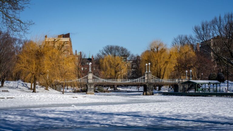
The Freedom Trail is a 2.5-mile path that weaves through the heart of Boston, Massachusetts, offering visitors a unique glimpse into the city's rich history and its pivotal role in the American Revolution. Marked by a distinctive red line, the trail guides you through 16 historically significant sites, including the Massachusetts State House, Paul Revere's House, and the Boston Common. Each stop along the trail tells a story of courage, sacrifice, and the fight for independence, making it an essential experience for history enthusiasts and casual visitors alike.
Walking the Freedom Trail provides not only a lesson in American history but also an opportunity to enjoy the vibrant atmosphere of Boston. The trail is lined with charming streets, beautiful parks, and a variety of shops and restaurants, allowing visitors to immerse themselves in the local culture. Guided tours are available, offering deeper insights into the historical context and significance of each site, while self-guided options allow for a more leisurely exploration at your own pace.
Continue reading the travel guide
Travel Guide to Freedom Trail
Practical considerations for visiting include wearing comfortable shoes, as the trail involves a fair amount of walking. The best time to visit is during the spring and fall when the weather is mild, and the foliage adds to the scenic beauty of the city. The Freedom Trail is easily accessible from various points in downtown Boston, making it a convenient addition to any itinerary.
Why Visit?
Visiting the Freedom Trail is a must for anyone interested in American history, as it provides a comprehensive overview of Boston's role in the fight for independence. The trail's combination of historical significance, beautiful scenery, and vibrant local culture creates a unique and enriching experience for all travelers.
Best Time to Visit
The ideal times to visit the Freedom Trail are during spring (April to June) and fall (September to November) when the weather is pleasant and the city is less crowded. Early mornings or late afternoons are also great for avoiding peak tourist times.
Ready to go? Plan your Freedom Trail trip → Good to know →
Plan your trip to Freedom Trail
Flights, accommodation and ways to get around — plan the details that matter to you.
Find flights to Freedom Trail
Nearest recommended airport search point: BOS.
See recent flight offersTo Boston €132From Boston €102
Recent flight offers
Compare available fares and routes for Freedom Trail.
Flights to Boston Arrivals · BOS
Cheap Flights to Boston for Freedom Trail (BOS)
Compare recent fares to Boston, the suggested airport search point for visiting Freedom Trail. Choose a listed deal or use the search box above to check prices from your airport.
Flights from Freedom Trail Departures · BOS
Cheap Flights from Boston (BOS)
Compare the latest low fares from Boston to popular destinations. Prices are updated regularly and may change based on travel dates and availability.
Stay & getting around
Choose a neighbourhood, then decide how you will get from the airport and around the city.
Where to stay Neighbourhoods and accommodation
Where to Stay in Freedom Trail
For convenient access to the Freedom Trail, consider staying in downtown Boston or the North End, where you'll find a range of accommodations from luxury hotels to budget-friendly options. These areas offer easy walking access to the trail and other attractions.
Getting around Airport transfers and local transport

Getting Around Freedom Trail
The Freedom Trail is primarily a walking route, making it easy to explore on foot. Boston's public transportation system, the MBTA, provides additional options for reaching the trail, with several subway stations and bus stops located nearby. The nearest airport is Logan International Airport (BOS), which is a short drive or public transit ride away.
Travel essentials
 Stay connected
 Flight delayed or cancelled?
Popular Activities in Freedom Trail
Good to know about Freedom Trail
Map & DirectionsChoose a map
Open Freedom Trail in your preferred map app.


Country factsCapital, language and useful details
Quick Facts
Country
Location
Practical Information
Climate
The United States has a diverse climate, ranging from arctic conditions in Alaska to tropical weather in Florida and Hawaii. Seasonal variations are significant, with each region offering unique weather patterns.
Money
The local currency is the US Dollar (USD). Credit and debit cards are widely accepted, but it's advisable to carry some cash for small purchases, local transport, and in rural areas.
Internet & SIM
Mobile coverage is generally good across urban areas, with various options for purchasing SIM cards or eSIMs available at airports and stores. Wi-Fi is commonly found in hotels, cafes, and public spaces.
Electricity
Voltage: 120 V
Frequency: 60 Hz
Safety
Emergency
911
Explore more in United States
Places to Visit in United States










































































Cities in United States



































About NomadRoute
NomadRoute helps travelers discover destinations, compare flight options, and find competitive fares from trusted airlines and travel providers worldwide. We do not sell airline tickets directly. Instead, we connect travelers with leading booking partners.
Discover More Destinations
Find low fares from trusted travel providers.
Compare options and book directly with partners.
Explore destinations and routes worldwide.
Photo · Phil Evenden · Pexels