
Travel Guide to Santa Ana Volcano
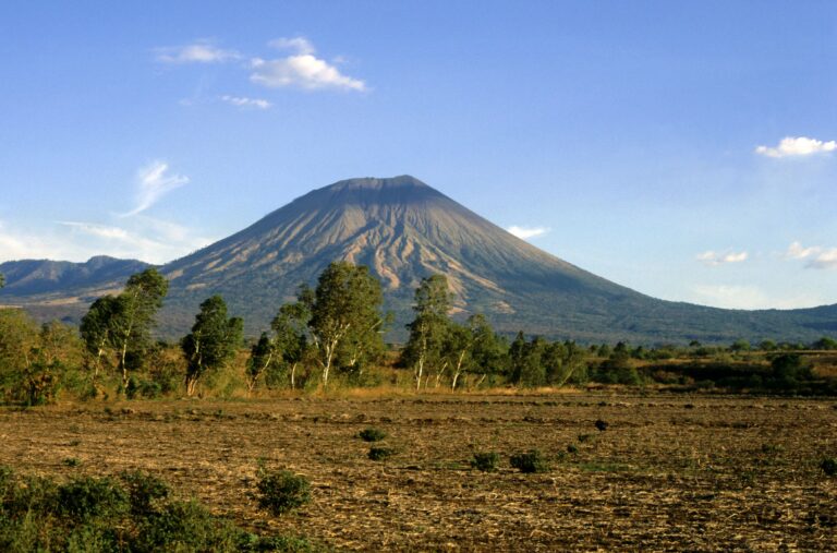
Santa Ana Volcano, also known as Ilamatepeq, is the highest volcano in El Salvador, standing at 2,381 meters (7,812 feet). This majestic stratovolcano is part of the Cerro Verde National Park and offers visitors a unique opportunity to explore its diverse ecosystems and stunning landscapes. The hike to the summit is popular among trekkers, taking approximately 4-5 hours to reach the top. As you ascend, you'll be treated to panoramic views of the surrounding mountains and the picturesque Coatepeque Lake.
The volcano's crater is particularly captivating, featuring a vibrant turquoise lake that fills the caldera. This stunning sight is a result of the volcanic activity and mineral deposits in the area. The region is also rich in biodiversity, with various species of flora and fauna, making it a great spot for nature enthusiasts and bird watchers.
Continue reading the travel guide
Travel Guide to Santa Ana Volcano
Visiting Santa Ana Volcano not only provides a thrilling adventure but also an insight into the geological history of El Salvador. The last major eruption occurred in 2005, and the area is still monitored for volcanic activity, adding an element of excitement to your visit. Be sure to bring plenty of water, wear sturdy hiking shoes, and consider hiring a local guide to enhance your experience and ensure safety during the hike.
Why Visit?
Santa Ana Volcano is a must-visit for those seeking adventure and stunning natural beauty. The challenging hike rewards you with breathtaking views and the chance to see a unique crater lake, making it a memorable experience for outdoor enthusiasts.
Best Time to Visit
The best time to visit Santa Ana Volcano is during the dry season, which runs from November to April. This period offers clear skies and pleasant temperatures, ideal for hiking. Early morning hikes are recommended to avoid the heat and enjoy the sunrise views from the summit.
Ready to go? Plan your Santa Ana Volcano trip → Good to know →
Plan your trip to Santa Ana Volcano
Flights, accommodation and ways to get around — plan the details that matter to you.
Find flights to Santa Ana Volcano
Nearest recommended airport search point: SAL.
See recent flight offersTo San Salvador €200From San Salvador €240
Recent flight offers
Compare available fares and routes for Santa Ana Volcano.
Flights to San Salvador Arrivals · SAL
Cheap Flights to San Salvador for Santa Ana Volcano (SAL)
Compare recent fares to San Salvador, the suggested airport search point for visiting Santa Ana Volcano. Choose a listed deal or use the search box above to check prices from your airport.
Flights from Santa Ana Volcano Departures · SAL
Cheap Flights from San Salvador (SAL)
Compare the latest low fares from San Salvador to popular destinations. Prices are updated regularly and may change based on travel dates and availability.
Stay & getting around
Choose a neighbourhood, then decide how you will get from the airport and around the city.
Where to stay Neighbourhoods and accommodation
Where to Stay in Santa Ana Volcano
While there are no accommodations directly on the volcano, nearby towns such as Santa Ana and Coatepeque offer various lodging options, from budget hostels to comfortable hotels. Staying in Santa Ana provides easy access to the volcano and other local attractions.
Getting around Airport transfers and local transport

Getting Around Santa Ana Volcano
To reach Santa Ana Volcano, travelers typically fly into El Salvador International Airport (SAL) and then take a bus or taxi to Santa Ana. Once in the area, local transport options include buses and taxis to the trailhead. Hiking is the primary way to explore the volcano itself.
Travel essentials
 Stay connected
 Flight delayed or cancelled?
Popular Activities in Santa Ana Volcano
Good to know about Santa Ana Volcano
Map & DirectionsChoose a map
Open Santa Ana Volcano in your preferred map app.


Country factsCapital, language and useful details
Quick Facts
Country
Location
Practical Information
Climate
El Salvador has a tropical climate, characterized by a wet season from May to October and a dry season from November to April. Coastal areas tend to be warmer, while the highlands can be cooler, especially at night.
Money
The local currency is the USD - US Dollar ($). Credit and debit cards are widely accepted in urban areas, but it's advisable to carry cash for small purchases, local transport, and in rural regions.
Internet & SIM
Mobile coverage is generally good in urban areas, with various providers offering SIM cards and eSIM options for tourists. Wi-Fi is available in many hotels, cafes, and restaurants, making it easy to stay connected during your visit.
Electricity
Voltage: 120 V
Frequency: 60 Hz
Safety
Emergency
911
Explore more in El Salvador
Places to Visit in El Salvador
Cities in El Salvador
About NomadRoute
NomadRoute helps travelers discover destinations, compare flight options, and find competitive fares from trusted airlines and travel providers worldwide. We do not sell airline tickets directly. Instead, we connect travelers with leading booking partners.
Find low fares from trusted travel providers.
Compare options and book directly with partners.
Explore destinations and routes worldwide.