
Travel Guide to Mount Karthala
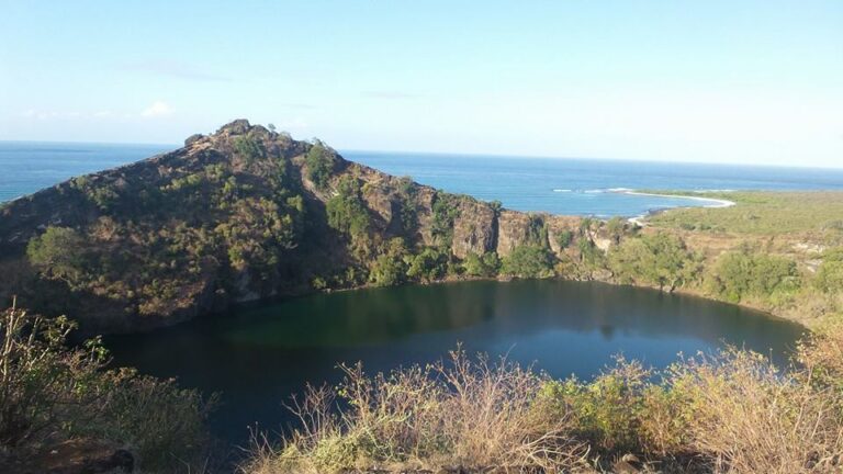
Mount Karthala, the highest peak in the Comoros, rises majestically to 2,361 meters and is an active volcano that last erupted in 2005. This remarkable mountain is not only a natural wonder but also a vital part of the island's ecosystem, housing diverse flora and fauna. The lush forests surrounding the volcano provide a habitat for unique species, making it a paradise for nature lovers and hikers.
Visitors to Mount Karthala can expect a challenging yet rewarding trek to the summit, where breathtaking views of the surrounding islands and the Indian Ocean await. The hike typically takes around six to eight hours, depending on the route chosen, and offers a chance to experience the rich volcanic landscape up close. Along the way, trekkers can explore various ecosystems, from dense forests to barren volcanic rock, showcasing the geological history of the region.
Continue reading the travel guide
Travel Guide to Mount Karthala
Practical considerations for planning a visit include ensuring proper hiking gear and being prepared for changing weather conditions, as temperatures can vary significantly at different elevations. Guided tours are recommended for those unfamiliar with the terrain, as local guides can provide valuable insights into the area's natural history and cultural significance. Mount Karthala is not just a hike; it’s an adventure that connects visitors with the stunning beauty of the Comoros Islands.
Why Visit?
Visiting Mount Karthala offers a unique opportunity to explore an active volcano while experiencing the breathtaking natural beauty and biodiversity of the Comoros. The challenging trek rewards adventurers with stunning panoramic views and a chance to witness the island's rich ecosystems firsthand.
Best Time to Visit
The best time to visit Mount Karthala is during the dry season, from May to October, when the weather is more stable and suitable for hiking. Early morning treks are recommended to avoid the heat and enjoy clearer views from the summit.
Ready to go? Plan your Mount Karthala trip → Good to know →
Plan your trip to Mount Karthala
Flights, accommodation and ways to get around — plan the details that matter to you.
Find flights to Mount Karthala
Nearest recommended airport search point: HAH.
See recent flight offers
Recent flight offers
Compare available fares and routes for Mount Karthala.
Stay & getting around
Choose a neighbourhood, then decide how you will get from the airport and around the city.
Where to stay Neighbourhoods and accommodation
Where to Stay in Mount Karthala
While there are no accommodations directly on Mount Karthala, travelers can stay in Moroni, the capital of Comoros, which offers various lodging options and serves as a convenient base for excursions to the mountain.
Getting around Airport transfers and local transport

Getting Around Mount Karthala
To reach Mount Karthala, travelers typically fly into Prince Said Ibrahim International Airport (HAH) in Moroni. From there, local transportation options such as taxis or rented vehicles can take visitors to the trailhead. Once at the mountain, guided tours are available for navigating the hiking routes.
Travel essentials
 Stay connected
 Flight delayed or cancelled?
Popular Activities in Mount Karthala
Good to know about Mount Karthala
Map & DirectionsChoose a map
Open Mount Karthala in your preferred map app.


Country factsCapital, language and useful details
Quick Facts
Country
Location
Practical Information
Climate
Comoros has a tropical climate with warm temperatures year-round. The dry season from May to October is characterized by less humidity and minimal rainfall, while the wet season from November to April can bring heavy rains, especially in January and February.
Money
The local currency is KMF - Comorian Franc. Cards are accepted in many places, but carrying some cash can be useful for small purchases, local transport, and rural areas.
Internet & SIM
Mobile coverage is generally good in urban areas, and SIM cards are available for purchase at the airport and local shops. Wi-Fi is accessible in many hotels and cafes, but may be limited in rural areas.
Electricity
Voltage: 220 / 230 V
Frequency: 50 Hz
Safety
Emergency
112 / 999
Explore more in Comoros
Places to Visit in Comoros
Cities in Comoros
About NomadRoute
NomadRoute helps travelers discover destinations, compare flight options, and find competitive fares from trusted airlines and travel providers worldwide. We do not sell airline tickets directly. Instead, we connect travelers with leading booking partners.
Discover More Destinations
Find low fares from trusted travel providers.
Compare options and book directly with partners.
Explore destinations and routes worldwide.
Photo · David Stanley from Nanaimo, Canada · Wikimedia Commons · CC BY 2.0