
Travel Guide to Teotihuacan Pyramids
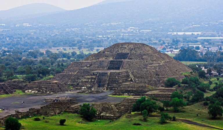
The Teotihuacan Pyramids, located just outside Mexico City, stand as one of the most significant archaeological sites in the world. This ancient city, which flourished between the 1st and 7th centuries AD, is celebrated for its impressive pyramids, including the Pyramid of the Sun and the Pyramid of the Moon. Visitors can explore the vast complex, which features well-preserved ruins, intricate murals, and the Avenue of the Dead, a central thoroughfare lined with temples and residential areas.
The atmosphere at Teotihuacan is both awe-inspiring and reflective, allowing visitors to connect with the ancient civilization that once thrived here. The site is not only a testament to the architectural prowess of its builders but also offers insights into their cultural and religious practices. As you walk among the towering pyramids, you can almost feel the echoes of history surrounding you.
Continue reading the travel guide
Travel Guide to Teotihuacan Pyramids
When planning your visit, consider arriving early in the morning to avoid crowds and enjoy the serene beauty of the site. Guided tours are available, providing valuable context and stories behind the structures. Be sure to wear comfortable shoes, as exploring the expansive grounds involves a fair amount of walking and climbing. The nearby town of San Juan Teotihuacan offers local dining options and souvenirs, making it a convenient base for your visit.
Why Visit?
Visiting the Teotihuacan Pyramids offers a unique opportunity to step back in time and experience one of the most important archaeological sites in the Americas. The grandeur of the pyramids, combined with their historical significance, makes for an unforgettable journey into ancient Mesoamerican culture.
Best Time to Visit
The best time to visit the Teotihuacan Pyramids is during the dry season, from November to April, when temperatures are milder and rainfall is minimal. Early mornings are ideal for avoiding crowds and enjoying the site in a peaceful atmosphere.
Ready to go? Plan your Teotihuacan Pyramids trip → Good to know →
Plan your trip to Teotihuacan Pyramids
Flights, accommodation and ways to get around — plan the details that matter to you.
Find flights to Teotihuacan Pyramids
Nearest recommended airport search point: MEX.
See recent flight offersTo Mexico City €74From Mexico City €53
Recent flight offers
Compare available fares and routes for Teotihuacan Pyramids.
Flights to Mexico City Arrivals · MEX
Cheap Flights to Mexico City for Teotihuacan Pyramids (MEX)
Compare recent fares to Mexico City, the suggested airport search point for visiting Teotihuacan Pyramids. Choose a listed deal or use the search box above to check prices from your airport.
Flights from Teotihuacan Pyramids Departures · MEX
Cheap Flights from Mexico City (MEX)
Compare the latest low fares from Mexico City to popular destinations. Prices are updated regularly and may change based on travel dates and availability.
Stay & getting around
Choose a neighbourhood, then decide how you will get from the airport and around the city.
Where to stay Neighbourhoods and accommodation
Where to Stay in Teotihuacan Pyramids
While there are no accommodations directly at the pyramids, the nearby town of San Juan Teotihuacan offers a range of hotels and guesthouses. Staying here allows for easy access to the site and local dining options.
Getting around Airport transfers and local transport

Getting Around Teotihuacan Pyramids
To reach the Teotihuacan Pyramids, travelers can take a bus from Mexico City, which typically takes about an hour. Once at the site, walking is the primary mode of transportation, as the attractions are spread out over a large area. Guided tours often include transportation from the city for added convenience.
Travel essentials
 Stay connected
 Flight delayed or cancelled?
Popular Activities in Teotihuacan Pyramids
Good to know about Teotihuacan Pyramids
Map & DirectionsChoose a map
Open Teotihuacan Pyramids in your preferred map app.




Country factsCapital, language and useful details
Quick Facts
Country
Location
Practical Information
Climate
Mexico has a diverse climate that varies significantly by region. Coastal areas typically enjoy a tropical climate, while central regions have a more temperate climate due to higher elevations. Rainy seasons occur mainly from May to October, with dry conditions from November to April.
Money
The local currency is the Mexican Peso (MXN). Credit and debit cards are widely accepted in urban areas, but it's advisable to carry cash for small purchases, local transport, and in rural regions.
Internet & SIM
Mobile coverage is generally good in urban areas, with various options for purchasing SIM cards or eSIMs available at airports and convenience stores. Wi-Fi is commonly found in hotels, cafes, and public spaces.
Electricity
Voltage: 127 V
Frequency: 60 Hz
Safety
Emergency
911
Explore more in Mexico
Places to Visit in Mexico



Cities in Mexico
About NomadRoute
NomadRoute helps travelers discover destinations, compare flight options, and find competitive fares from trusted airlines and travel providers worldwide. We do not sell airline tickets directly. Instead, we connect travelers with leading booking partners.
Discover More Destinations
Find low fares from trusted travel providers.
Compare options and book directly with partners.
Explore destinations and routes worldwide.